[Leicester North]
[Abbey Lane Area]
[North Viaduct]
[Leicester Central]
[Braunstone Gate]
[Goods Yard]
[Aylestone]
[Bridging the Gap]
[Notes for Visitors]
[Old Photographs]
[Archive]
[Links]
This section covers the line south of the station, in the West Bridge and Braunstone Gate area.
Click here for a map of this area from Bing
Notes on using the Bing Map
The map linked to is the Ordnance
Survey map.
To see an aerial photograph of the area covered by the map click on the tab labelled “Ordnance Survey” near top right of the screen and select ‘Aerial’ from the drop-down list.
When
finished with the map click on the browser ‘Back’ button till you return here.
The River Soar and the Grand Union Canal feature prominently in this area. The River Soar splits into two between Upperton Road, at the south of the Great Central goods yard, to West
Bridge.
The canalised River Soar is the east arm and flows along to the east of the goods yard site, across Western Boulevard. It was straightened out as a flood prevention scheme just before the Great Central was
built at the end of the 19th century, and was crossed by the Great Central at West Bridge.
The “Old River Soar” is the non-navigable west arm and is bridged by the Great Central several times.
This area of Leicester has undergone major changes since the Great Central Railway viaduct and bridges were demolished. To illustrate these changes some before and after photographs are shown here, while this site also has more old photographs of the demolition around West Bridge.

Panorama photograph at West Bridge in 1978, looking north along the Grand Union Canal, part of the canalised River Soar. Leicester Central station is off on the far right.

The GCR bridge over the Grand Union Canal, looking north in 1974.
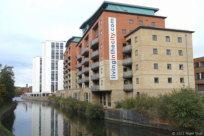
The same view in 2021 as the previous old photograph shows that all signs of the railway bridge here are long gone, except for the blue bricks on the far side of the river, just below the right end of the new apartment block, which were in the base of the bridge abutment. The factories along the bank of the canal have been replaced by apartment blocks. Looking north towards Leicester Central Station.

The viaduct immediately south of the River Soar/Grand Union Canal has long been demolished, and here in December 2010 the viaduct further on at Braunstone Gate was being demolished (looking south). The digger is standing on the site of the “Pump & Tap” pub which was demolished the previous year.

The magnificent Bowstring bridge in Braunstone Gate before its demolition in 2009 after a prolonged campaign to save it, looking south-east. For more photographs of the bridge and its demolition see the page Old Photographs: Leicester Demolition 2.

The view in Braunstone Gate in December 2010 after the demolition of the Bowstring Bridge and during the demolition of the north part of the viaduct.

The new swimming pool and sports hall built on the site of the bridge abutment and viaduct on the north side of the Bowstring bridge, looking south.
Update March 2013: the Leicester Mercury reported that the city council had sold the remaining viaduct visible in the distance for demolition and redevelopment.

In September 2010 a commemorative plaque was put on the wall of The Bowstring restaurant, opposite the site of the bowstring bridge.

The plaque commemorating the bowstring bridge.

This length of viaduct is immediately south of the site of the bowstring bridge. On the old GCR maps these arches are marked as ‘Stables’, presumably for
the horses used for conveying the carts with deliveries from the goods yard which was round the corner. The outside of the new swimming pool can be seen on the far left.
Update March 2013:
This length of viaduct has been sold for demolition and redevelopment.
Update March 2019:
Plans have been published to demolish the viaduct here and build nine storeys of student accommodation which would also straddle the Old River Soar, see below.

On the left can be seen the other side of the viaduct shown in the previous photograph which was used as stables. The Bowstring bridge spanned both the Old River Soar and Western Boulevard here. The swimming pool and sports hall opposite were built on the site of the bridge abutment and viaduct on the north side.

Another bridge over the Old River Soar 50 yards south of Braunstone Gate bridge, looking south near where the previous photograph was taken. The path on the far left is the Great Central Way which joins the track bed here and follows it all the way to the outskirts of Leicester. At one time the Great Central way footpath crossed this bridge and headed over the Bowstring bridge, which was to the right.

The original route of the Great Central Way footpath followed the GCR track bed to the north over the Old River Soar bridge and the Bowstring bridge. The footpath was later closed here and diverted off to the right, though still follows the track bed southwards.

Looking northwards through the fence and across the bridge over the Old River Soar. The wooden fence in the distance protects the gap which the Bowstring bridge at Braunstone Gate used to span, while beyond is an apartment block which was built over the route, next to the canal/river Soar shown in the first photograph on this page.
[Leicester North]
[Abbey Lane Area]
[North Viaduct]
[Leicester Central]
[Braunstone Gate]
[Goods Yard]
[Aylestone]
[Bridging the Gap]
[Notes for Visitors]
[Old Photographs]
[Archive]
[Links]
© 2001-2026 Text and photographs copyright Nigel Tout, unless otherwise indicated.